


The Habitable Planet: A Systems Approach to Environmental Science
Oceans Online Textbook

1. Introduction
Unit 3 // Section 1
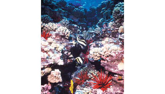
Although it may seem counterintuitive, the oceans play a major part in creating conditions for life on land. Together with the atmosphere, oceans regulate global temperatures, shape weather and climate patterns, and cycle elements through the biosphere. They also contain nearly all of the water on Earth’s surface and are an important food source. Life on Earth originated in the oceans, and they are home to many unique ecosystems that are important sources of biodiversity, from coral reefs to polar sea ice communities (Fig. 1).

Figure 1. Coral reef in the Hawaiian islands
Coral reefs are among the most biologically diverse ecosystems on Earth.
Source: ©United States Geological Survey.
Scientific understanding of the oceans made great advances during the 20th century, but we still know relatively little about such central issues as the abundance and diversity of marine species, the declining health of coral reefs, and how future changes in global climate might affect ocean circulation. Technologies such as remote sensing from satellites are making it possible to collect and analyze more of the physical, chemical, and biological data that researchers need to address these questions.
However, the sheer size of the oceans and the difficulties involved in exploring them—especially at depths where no light penetrates and overlying water generates crushing pressures—make it an ongoing challenge to understand how the seas work. In an effort to fill this gap, several U.S. expert panels recently have recommended investing in a national ocean exploration program and a broad-scale system like the National Weather Service to observe and forecast ocean conditions (footnote 1).
“[T]he ocean remains one of the least explored and understood environments on the planet—a frontier for discoveries that could provide important benefits . . . . Ocean science and technology will play an increasingly central role in the multidisciplinary study and management of the whole-Earth system.”
U.S. Commission on Ocean Policy,
An Ocean Blueprint for the 21st Century
(2004)
This unit explores the working of ocean currents and circulation patterns and their influence on global climate cycles. It then turns to biological activity in the oceans, focusing on microscopic plankton that form the base of ocean food webs, and the influence of physical conditions like temperatures and currents on ocean food production.
Finally, this unit looks at one of the most important global regulating mechanisms: the so-called “biological pump” in which plankton take up carbon from the atmosphere, then carry it to the deep ocean where it can remain for thousands of years. This process is centrally important to life on Earth for several reasons. First, as discussed in Unit 2, “Atmosphere,” the process of photosynthesis releases one molecule of oxygen to the atmosphere for every carbon atom that is packaged in organic carbon. Phytoplankton photosynthesis produces about half of the world’s oxygen supply. And as we will see, by exporting carbon to deep waters, the biological pump helps to regulate Earth’s energy balance and partially offsets rising CO2 concentrations in the atmosphere.
Despite their global scope, the oceans are highly vulnerable to human impacts, including marine pollution (discussed in Unit 8, “Water Resources”) and over-fishing (addressed in Unit 9, “Biodiversity Decline”). Most profoundly, scientists increasingly agree that human-induced climate change could affect ocean temperatures, circulation, and carbon cycling over the next century. Scientists widely agree today that global climate change is causing ocean temperatures to rise and is changing fresh and saltwater balances in many areas of the seas. Before we consider how ocean systems may be affected by global climate change, however, it is essential to understand how biological and physical processes interact normally in the oceans and how the oceans help to shape conditions for life on Earth. (For more details on how global climate change affects the oceans, see Unit 12, “Earth’s Changing Climate,” and Unit 13, “Looking Forward: Our Global Experiment.”)
2. Ocean Structure and Composition
Unit 3 // Section 2
Like the atmosphere, the oceans are not uniformly mixed but are structured in layers with distinct properties (Fig. 2). Pressure increases with depth as the weight of the overlying air and water increase. Unlike the atmosphere, however, pressure changes at a linear rate rather than exponentially because water is almost impossible to compress, so its mass is equally distributed throughout a vertical water column. Atmospheric pressure at sea level is 14.7 pounds per square inch (also referred to as “one atmosphere”), and pressure increases by an additional atmosphere for every 10 meters of descent under water. This gradient is well known to scuba divers who have experienced painful “ear squeeze” from pressure differences between the air in their ears and the seawater around them.

Figure 2. Layers of the ocean
Source: ©National Oceanic and Atmospheric Administration. National Weather Service.
Oceans are divided into zones that offer a wide range of conditions for life.
The Epipelagic, or sunlight, zone (so-called because most visible light in the oceans is found here) comprises the first 200 meters below the surface, and is warm and mixed by winds and wave action. Surface waters account for about 2 percent of total worldwide ocean volume. At a depth of about 200 meters, the Continental Shelf (the submerged border of the continents) begins to slope more sharply downward, marking the start of the Mesopelagic, or twilight, zone. Here water temperature falls rapidly with depth to less than 5°C at 1,000 meters. This sharp transition, which is called the thermocline, inhibits vertical mixing between denser, colder water at depths and warmer water nearer the surface. About 18 percent of the total volume of the oceans is within this zone.
Below 1,000 meters, in the Bathypelagic, or midnight, zone, water is almost uniformly cold, approximately 4°C. No sunlight penetrates to this level, and pressure at the bottom of the zone (around 4,000 meters depth) is about 5,880 pounds per square inch. Little life exists at the Abyssopelagic (abyssal) zone, which reaches to the ocean floor at a depth of about 6,000 meters. Together, these cold, deep layers contain about 80 percent of the total volume of the ocean.
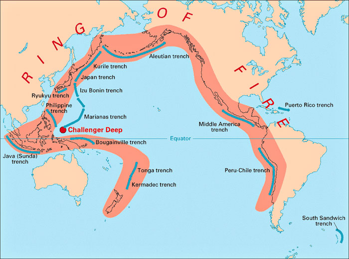
The deepest points in the ocean lie in long, narrow trenches that occur at convergence zones—points where two oceanic plates collide and one is driven beneath the other. This region is called the Hadal zone. The deepest oceanic trench measured to date is the Marianas Trench near the Philippines, which reaches more than 10,000 meters below sea level. Highly specialized life forms, including fish, shrimps, sea cucumbers, and microbes, survive even at these depths.
Movement along colliding plates in convergence zones frequently generates earthquakes and tsunamis; an earthquake measuring 9.15 on the Richter scale off the coast of Sumatra triggered the Indian Ocean tsunami that killed more than 230,000 people on December 26, 2004. Volcanoes often erupt near convergence zones when hot magma escapes through rock fractures. Many of the world’s largest ocean trenches, therefore, are located along the “Ring of Fire,” an arc of volcanoes around the Pacific Ocean that denotes convergent plates margins (Fig. 3).
 Figure 3. Ocean trenches and the “Ring of Fire”
Source: © United States Department of the Interior. United States Geological Survey.
The “Ring of Fire” is one of the most volcanically and seismically active regions on Earth.
3. Ocean Currents
Unit 3 // Section 3
Mixing is a key dynamic in the oceans, creating currents and exchanges between cold, deep waters and warmer surface waters. These processes redistribute heat from low to high latitudes, carry nutrients from deep waters to the surface, and shape the climates of coastal regions.
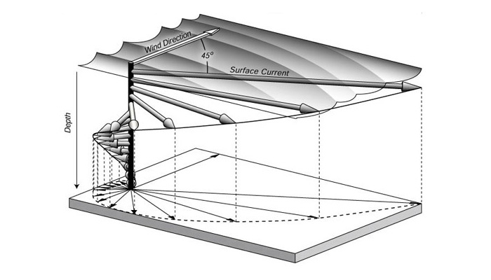
Several types of forces cause ocean mixing. Waves and surface currents are caused mainly by winds. When winds “pile up” water in the upper ocean, they create an area of high pressure and water flows from high to low pressure zones. Ocean currents tend to follow Earth’s major wind patterns, but with a difference: the Coriolis force deflects surface currents at an angle of about 45 degrees to the wind—to the right in the Northern Hemisphere, left in the Southern Hemisphere. (For more about the Coriolis force, see Unit 2, “Atmosphere.”) This pattern is called Ekman transport, after Swedish oceanographer Vagn Ekman. Each layer of the ocean transfers momentum to the water beneath it, which moves further to the right (left), producing a spiral effect (Fig. 4).

Figure 4. Ekman spiral
Source: © 2004. Oceanworld, Texas A&M University.
Ekman spirals contribute to ocean current patterns.
At deeper levels, ocean mixing is caused by differences in density between colder, saltier water and warmer, fresher water. Because the density of water increases as it becomes colder and saltier, it sinks at high latitudes and is replaced by warm water flowing northward from the tropics. (This pattern, called the Thermohaline Circulation, is a key mechanism that helps to regulate Earth’s climate and is discussed further below and in Section 4.) Cold water typically flows below warmer water, but when winds blowing along coastlines deflect warm surface currents away from shore through Ekman transport, they allow cold, nutrient-rich water to rise to the surface. This coastal upwelling process occurs against western coastlines in the Atlantic, Pacific, and Indian oceans.
The combined effects of these forces create circular currents called gyres in the world’s largest oceans, centered at about 25° to 30° north and south latitudes. Gyres rotate clockwise in the Northern Hemisphere and counter-clockwise in the Southern Hemisphere, driven by easterly winds at low latitudes and westerly winds at high latitudes. Due to a combination of friction and planetary rotation, currents on the western boundaries of ocean gyres are narrower and flow faster than eastern boundary currents. Warm surface currents flow out of ocean gyres from the tropics to higher latitudes, and cold surface currents flow from colder latitudes toward the equator (Fig. 5).

Figure 5. Ocean currents
Ocean currents flow in distinct patterns generated by wind, Earth’s rotation, water heat content and salinity, and bottom topography.
Source: © 2004. Arctic Climate Impact Assessment, Graphics Set 1, p. 21.
How does ocean circulation affect Earth’s climate? The oceans redistribute heat from high to low latitudes by moving warm water from the equator toward the poles. They also cause a net transfer of heat from the Southern to the Northern Hemisphere. As currents flow, they warm or cool the overlying atmosphere. The most famous example is the Gulf Stream, the fast-moving western boundary current that flows north through the Atlantic Ocean and makes northern Europe much warmer than Canadian provinces lying at the same latitudes.
In areas where coastal upwelling brings cold water up from the depths, cold currents have the opposite effect. As one illustration, San Diego, California, and Columbia, South Carolina, lie at the same latitude, but coastal upwelling in the eastern Pacific brings cold water into the California Current system, which runs south along the California coast. This process helps to keep peak summer temperatures in San Diego at about 78°F, compared to 95°F in Columbia.
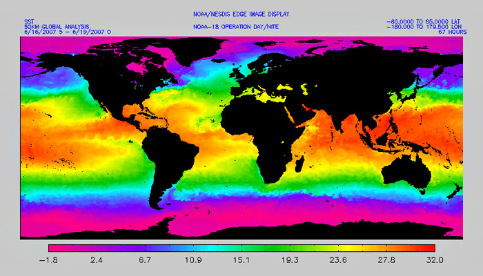
Ocean waters are warmest in the tropics and coldest at the poles because the sun heats the equator more strongly than high latitudes. Surface water temperatures can be 30°C warmer at the equator than in polar regions (Fig. 6). Short-term variations in ocean surface temperatures, from day to night and summer to winter, are mainly influenced by the sun’s energy. However, as we will see below in Section 5, some longer-term temperature changes are not driven directly by the sun but rather by complex atmosphere/ocean interactions that occur on seasonal, annual, or multi-year cycles.

Figure 6. Global sea surface temperatures, July 1–4, 2005
Sunlight warms Earth unevenly, so ocean temperatures vary widely with latitude.
Source: © NOAA Satellite and Information Service. National Environment Satellite, Data, and Information Services.
The oceans respond to temperature changes more slowly than the atmosphere because water has a higher specific heat capacity (SHC) than air, which means that it takes more energy input to increase its temperature (about four times more for liquid water). Because water warms and cools more slowly than land, oceans tend to moderate climates in many coastal areas: seaside regions are typically warmer in winter and cooler in summer than inland locations. On a larger scale, by absorbing heat the oceans are delaying the full impact of rising temperatures due to global climate change by decades to centuries. (For more details, see Unit 13, “Looking Forward: Our Global Experiment.”)
4. Thermohaline Circulation
Unit 3 // Section 4
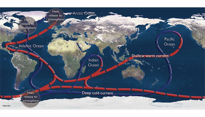
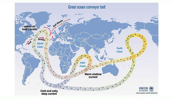
The thermohaline circulation is often referred to as the “global conveyor belt” because it moves large volumes of water along a course through the Atlantic, Pacific, and Indian oceans. Cold, salty water sinks in the Norwegian Sea and travels south to the Antarctic, then east to the Pacific. Here water warms and rises, then reverses course and follows an upper-ocean course back through the Indian Ocean and around Cape Horn to the Atlantic (Fig. 7). The current has a flow equal to that of 100 Amazon rivers.

Figure 7. Thermohaline circulation
The thermohaline circulation is a global current that moves water between ocean basins and from the surface to ocean depths.
Source: © United Nations Environmental Programme/GRID Arendal.
The thermohaline circulation is driven by buoyancy differences in the upper ocean that arise from temperature differences (thermal forcing) and salinity differences (haline forcing). As noted in the previous section, ocean temperatures are lower in polar regions and higher at the equator because the latter receives more radiant energy from the sun. Cold water sinks in polar areas and warmer, less dense water floats on top.
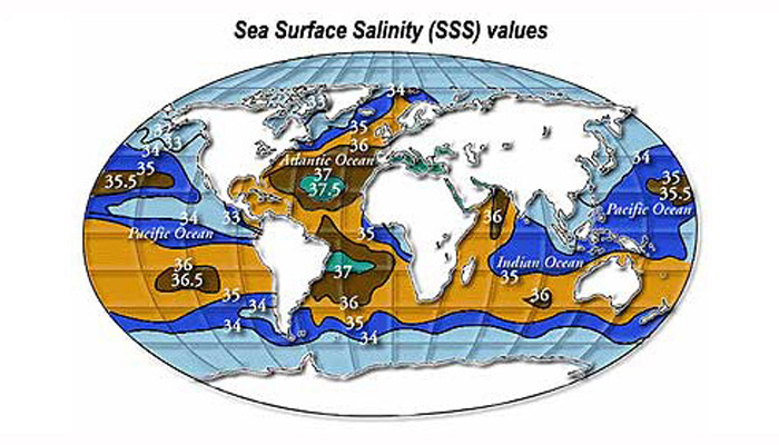
In contrast, salinity differences are caused by evaporation, precipitation, freshwater runoff, and sea ice formation. Evaporation rates are highest in subtropical regions where Hadley circulation loops produce descending currents of warm, dry air (for more details on Hadley circulation, see Unit 2, “Atmosphere”). When seawater evaporates or freezes, most of its salt content is left behind in the ocean, so high rates of evaporation in the subtropics raise salinity levels. Seawater is relatively less saline at higher latitudes because these regions have more precipitation than evaporation. In addition, melting sea ice returns fresh water to the oceans (Fig. 8).

Figure 8. Sea surface salinity (SSS) values
Small variations in sea surface salinity can affect ocean circulation and the water cycle.
Source: © National Aeronautics and Space Administraton.
Putting these two factors together, water cools in the North Atlantic and becomes dense enough to sink. Surface currents carry warm, salty water poleward to replace it. In the Indian and Pacific oceans, deep water returns to the surface through upwellings.
As sea ice forms and melts at the poles, it influences ocean circulation by altering the salinity of surface waters. When sea water freezes into ice, it ejects its salt content into the surrounding water, so waters near the surface become saltier and dense enough to sink. This process propels cold waters to depth and draws warmer waters northward in their place. Two factors can make polar waters less salty and reduce this flow. First, warmer temperatures on land increase glacial melting, which sends higher flows of fresh water into the oceans. Since fresh water is less dense than salt water, it floats on the ocean’s surface like a film of oil, reducing vertical mixing and slowing the formation of deepwater. Warmer air temperatures also reduce the formation of sea ice, so less salt is ejected into northern waters.
Within the ocean, distinct water masses with physical properties that are different from the surrounding water form and circulate, much like air masses in the atmosphere. Several important water masses help to drive the thermohaline circulation. North Atlantic Deep Water (NADW), the biggest water mass in the oceans, forms in the North Atlantic and runs down the coast of Canada, eastward into the Atlantic, and south past the tip of South America. NADW forms in the area where the North Atlantic Drift (the northern extension of the Gulf Stream) ends, so it helps to pull the Gulf Stream northward. If the NADW were to slow down or stop forming, as has happened in the past, this could weaken the Gulf Stream and the North Atlantic Drift and cool the climate of northwest Europe. (For more details, see Unit 13, “Looking Forward: Our Global Experiment.”)
Another cold water mass, Antarctic Bottom Water (AABW), is the densest water mass in the oceans. It forms when cold, salty water sinks in the seas surrounding Antarctica, carrying oxygen and nutrients with it, and flows northward along the sea floor underneath the North Atlantic Deep Water, displacing the waters above it and helping to propel the Thermohaline Circulation (Fig. 9).

Figure 9. Cold water masses
Water masses with different temperatures and salinities help to drive ocean circulation.
Source: © Wikimedia Commons. Creative Commons Attribution Share-A-Like 1.0 license.
This circulation pattern is not constant or permanent. Studies of Earth’s climate history have linked changes in the strength of the thermohaline circulation to broader climate changes. At times when the conveyor belt slowed down, temperatures in the Northern Hemisphere fell; when the circulation intensified, temperatures in the region rose. Current analyses suggest that as the oceans warm in response to global climate change, the Thermohaline circulation could weaken again, possibly shutting down completely in extreme scenarios. (For more details, see Unit 13, “Looking Forward: Our Global Experiment.”)
5. Ocean Circulation and Climate Cycles
Unit 3 // Section 5
Ocean circulation patterns are important contributing factors in many well-known and predictable climate variations. Weather patterns in a given region of the Earth can be affected at any given time by one or more of these climate cycles, depending on the areas that they cover and whether they overlap in time. Measuring the variables that signal switches in climate cycles, such as changes in ocean temperature and atmospheric pressure, is an important research focus for ocean and atmospheric scientists who are working to make better predictions of climate and weather cycles.
Monsoons are a well-known example of a seasonal climate cycle. These storms arise when land and water heat up at sharply different rates. As land temperatures increase during summer months, hot air masses rise over the land and create low-pressure zones. At the surface, ocean winds blow toward land carrying moist ocean air. When these winds flow over land and are lifted up by mountains, their moisture condenses and produces torrential rainfalls.
In winter this pattern reverses: land cools more quickly than water, so air rises over the warm oceans and draws winds from the continents, producing high pressure and clear weather over land. In Asia, winter monsoons occur from December through March and summer monsoons take place from June through September (Fig. 10). Summer monsoons also occur from July through September in Mexico and the southwestern United States.

Figure 10. Monsoon rain clouds near Nagercoil, India, August 2006
Monsoon rains are crucial to agricultural production in India.
Source: © Wikimedia Commons. Creative Commons Attribution Share-A-Like 1.0 license.
Hurricanes develop on an annual cycle generated by atmospheric and ocean conditions that occur from June through November in the Atlantic and from May through November in the eastern Pacific. The main requirements for hurricanes to develop are warm ocean waters (at least 26.5°C/80°F), plenty of atmospheric moisture, and weak easterly trade winds (for more details, see Unit 2, “Atmosphere”). A typical North Atlantic hurricane season produces eleven named storms, of which six become hurricanes, including two major hurricanes (Category 3 strength or higher).
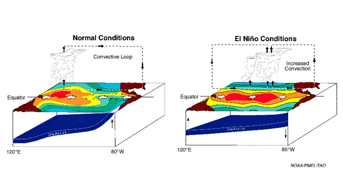
The best-known multi-annual climate cycle is the El Niño Southern Oscillation (ENSO), which is caused every three to seven years by changes in atmospheric and ocean conditions over the Pacific Ocean. Normally, as shown in Fig. 5 above, a large gyre sits over the southern Pacific. When this gyre is strong, winds along the coast of South America and trade winds that blow west along the Equator are strong. These winds pile warm surface waters up in the western Pacific and produce coastal upwelling of cold, nutrient-rich water that supports major fisheries near the coast of South America (Fig. 11, left image). This pattern is called the Walker Circulation, named for its discoverer, British scientist Sir Gilbert Walker.
In an El Niño year, the gyre weakens and this pattern flips into reverse. Atmospheric pressure rises over Asia and falls over South America, equatorial trade winds weaken, and warm water moves eastward toward South and Central America and California (Fig. 11, right image). Coastal upwelling in the eastern Pacific dwindles or stops. Warm, moist air rises over the west coasts of North and South America, causing heavy rains and landslides as droughts occur in Indonesia and other Asian countries. The event was originally named El Niño (meaning “the Christ Child”) by South American fishermen because coastal waters often began warming around Christmas. Major El Niño events occurred in 1982–1983 and 1997–1998: each cycle killed several thousand people (mostly through flooding), triggered major forest fires in Asia, and caused millions of dollars’ worth of property damage.

Figure 11. Normal and El Niño conditions
El Niño and La Niña affect weather and climate around the globe.
Source: © National Oceanic and Atmospheric Administration, Pacific Marine Environmental Laboratory, Tropical Atmosphere Ocean Project.
During a La Niña event (an unusually intensive reverse phase of El Niño), Pacific water temperatures become unusually cold and cold-water upwelling increases along western South America. La Niña episodes produce unusually wet weather in Asia and drier than normal conditions in much of the United States. A full El Niño/La Niña cycle lasts for about four years.
Other ocean/atmosphere climate cycles happen on even longer time frames. The Pacific Decadal Oscillation (PDO) is a 20- to 30-year cycle in the North Pacific Ocean. Positive PDO indices (warm phases) are characterized by warm Sea Surface Temperature (SST) anomalies along the Pacific coast and cool SST anomalies in the central North Pacific. Negative PDO indices (cold phases) correspond to the opposite anomalies along the coast and offshore. They intensify the Aleutian Low pressure cell, a semi-permanent atmospheric pressure cell that settles over the North Pacific from late fall to spring.
Cool PDO phases are well correlated with cooler and wetter than average weather in the western United States. During the warm phase of the PDO, the western Pacific cools and the eastern Pacific warms, producing weather that is slightly warmer and drier than normal in the western states. Since the North American climate anomalies associated with PDO extremes are similar to those associated with the ENSO cycle, the PDO can be seen as a long-lived El Niño-like pattern in Pacific climate variability.
The North Atlantic Oscillation (NAO), another multi-decadal cycle, refers to a north-south oscillation in the intensities of a low-pressure region south of Iceland and a high-pressure region near the Azores. Positive NAO indices mark periods when the differences in Sea Level Pressures (SLP) are greatest between these two regions. Under these conditions, the westerly winds that pass from North America between the high and low-pressure regions and on to Europe are unusually strong, and the strength of Northeast Trade Winds is also enhanced. This strong pressure differential produces warm, mild winters in the eastern United States and warm, wet winters in Europe as storms crossing the Atlantic are steered on a northerly path.
In the negative phase, pressure weakens in the subtropics, so winter storms cross the Atlantic on a more direct route from west to east. Both the eastern United States and Europe experience colder winters, but temperatures are milder in Greenland because less cold air reaches its latitude.
6. Biological Activity in the Upper Ocean
Unit 3 // Section 6
Most living organisms in the ocean, including most that live in the deepest waters, are nourished directly or indirectly by plankton that live at the surface. Marine biologists are still discovering new life forms of all shapes and sizes in the sea, but some of the most important findings in recent decades concern the ocean’s tiniest life forms: microbes that produce organic matter (mostly through photosynthesis) and form the base of ocean food chains.
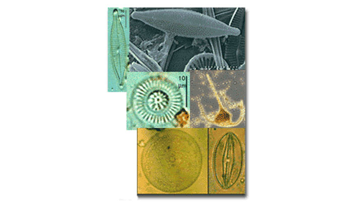
Measured in caloric output per year, the oceans account for nearly half of the world’s gross primary production. Nearly all of it takes place in a thin upper layer of the oceans and is done by phytoplankton—microorganisms that typically measure one-twentieth of a millimeter across at the largest and live for one to five days (Fig. 12). But what phytoplankton lack in size, they make up in numbers. Two types of cyanobacteria (blue-green algae), Synechococcus and Prochlorococcus, may be the two most abundant organisms on Earth and are found in concentrations of up to 500,000 cells per milliliter of seawater (footnote 2).

Figure 12. Marine phytoplankton
Phytoplankton form the base of marine food webs.
Source: © United States Geological Survey.
Since average temperatures are much less variable in the ocean than on land, temperature is less of a limiting factor for primary production in the oceans. However, light is key. As sunlight penetrates down through the ocean, it is absorbed or scattered by water and by particles floating in the water. The compensation depth, where net energy produced from photosynthesis equals the energy that producers use for respiration, occurs at a depth where light is reduced to about 1 percent of its strength at the surface. In clear water this may be as deep as 110 meters, but in turbid coastal water it may be less than 20 meters. Activities that make water more murky, such as dredging or water pollution, thus are likely to reduce biological productivity in the areas where they occur.
Mixing also affects how much light phytoplankton receive. If winds stir the ocean so that the mixed layer extends far below the compensation zone, phytoplankton will be pushed down levels where there is not enough light for photosynthesis, so their net production will be lower than if they drift constantly in well-lit water. In areas of the ocean where wind speeds vary widely from season to season, primary productivity may rise and fall accordingly.
In addition to light, phytoplankton need nutrients for photosynthesis. Carbon is available in the form of CO2 from the atmosphere. Other important macronutrients including nitrogen (N), phosphorus (P), and silicon (Si), and micronutrients such as iron (Fe), are dissolved in seawater. On average, phytoplankton use nutrients in a ratio of 106 C: 16N: 1P: .001 Fe, so if one of these elements runs out in the mixed layer, productivity goes down. Ocean mixing and coastal upwelling bring new supplies of nutrients up from deeper waters.
When optimal light, temperature, and nutrient conditions occur, and limited numbers of grazers (larger organisms that feed on phytoplankton) are present, plankton population explosions called blooms occur. Grazers reproduce more slowly than phytoplankton, so it takes time for them to catch up to their food supply. Major blooms can color large stretches of ocean water red, brown, or yellow-green depending on what species is present (hence the popular term “red tide,” although tides do not cause blooms). Many of these events are not harmful in themselves, but they deplete oxygen in the water when the organisms die and decompose. Some types of phytoplankton algae produce neurotoxins, so blooms of these varieties are dangerous to swimmers and consumers of fish or shellfish from the affected area.
Blooms can be triggered by runoff that carries fertilizer or chemicals into ocean waters or by storms that mix ocean waters and bring nutrients to the surface. They often occur in spring, when rising water temperatures and longer daylight hours stimulate phytoplankton to increase their activity levels after slow or dormant periods during winter. Most plankton blooms are beneficial to ocean life because they increase the availability of organic material, much like the flowering that takes place on land in spring.
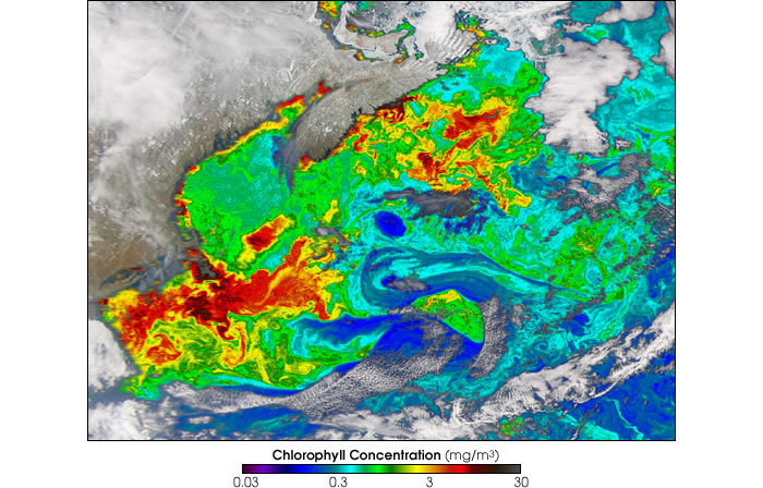
A massive spring bloom occurs each year in the North Atlantic from March through June, raising ocean productivity levels from North Carolina to Canada. This bloom extends all the way north to the southern edge of Arctic sea ice and moves northward through the spring and summer as ice melts. Figure 13 shows a portion of the bloom.

Figure 13. North Atlantic spring bloom, March 28, 2003 (Cape Cod to Newfoundland shown)
The North Atlantic spring plankton bloom starts near Bermuda and spreads north past Iceland.
Source: © National Aeronautics and Space Administration. Earth Observatory.
Phytoplankton are eaten by animal microorganisms such as zooplankton, which range from single-celled creatures like foraminifera (small amoebae with calcium carbonate shells) to larger organisms such as krill and jellyfish. Copepods, the most abundant type of small crustaceans, are one to two millimeters long and serve as important food sources for fish, whales, and seabirds. Phytoplankton blooms attract zooplankton, which in turn are eaten by larger predators. “Phytoplankton are the plants of the ocean and the base of the food web,” says MIT biologist Penny Chisholm. “If they weren’t there, there would be nothing else living in the oceans.”
Climate cycles can have major impacts on biological productivity in the oceans. When Pacific coastal upwelling off South America slows or stops during an El Niño event, plankton growth falls, reducing food supplies for anchovies and sardines that prey on the plankton. These fish die off or move to colder waters, which in turn reduces food for large predators like tuna, sea lions, and seabirds. Major El Niño events in the 20th century devastated the South American fishing industry and killed thousands of predator species as far north as the Bering Straits.
Other climate cycles have similar impacts. Generally, warm phases of the Pacific Decadal Oscillation decrease productivity off of the western United States and cold phases increase it. Decadal fluctuations in salmon, several ground fish, albacore, seabirds, and marine mammals in the North Pacific have been associated with the PDO. The mechanisms underlying these associations are speculative, but probably represent a combined effect of atmospheric conditions such as wind strength; upper ocean physical conditions, such as current strength, depth of wind mixing, and nutrient availability; and biological responses to these conditions across many trophic levels. Similarly, successful recruitment of several species of fish, including sardines and cod, has been associated with different phases of the NAO in different regions of the North Atlantic.
7. The "Biological Pump"
Unit 3 // Section 7
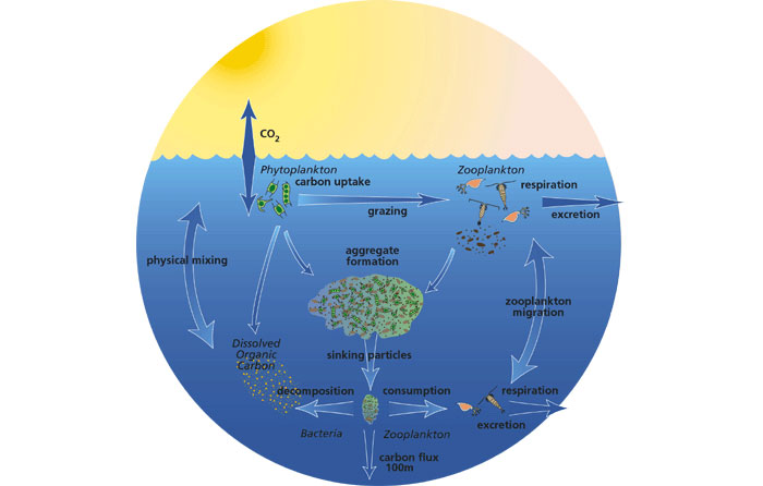
Deep waters provide nutrients that plankton need for primary production in the upper ocean, but how do these nutrients get to the ocean depths? They are carried down from the surface in a rain of particles often referred to as marine snow, which includes fecal pellets from zooplankton, shells from dead plankton, and other bits of organic material from dead or dying microorganisms. Many of these bits are almost invisible and too light to sink (a fecal pellet is about the size of a typeset comma), but when they stick together and form clumps called aggregates, the clumps eventually become heavier. Bacteria, plankton, and larger creatures feed on the pellets as they sink, then excrete wastes that add to the snowfall. Particles can travel to the deep ocean floor in spans of days or weeks.
When marine snow reaches deep waters, some is consumed by bottom-dwellers and microbes who depend on it as a food source since they live below the zones where light penetrates. Some is oxidized, releasing CO2, nitrate, and phosphate and recycling nutrients into deep waters. The remainder is buried in sediments; organic-rich carbon buried thousands of years ago in ancient inland seas and coastal margins is the source of today’s offshore oil and gas deposits.
In addition to recycling nutrients and providing food for deep-dwelling species, this flow of particles to ocean depths is a critical link in the global carbon cycle, dubbed the biological pump by oceanographer and climate scientist Roger Revelle. Plankton take up carbon from the atmosphere in two ways: they fix CO2 as organic carbon during photosynthesis and form shells from calcium carbonate. Marine snow carries both of these forms of carbon away from the atmosphere and surface waters to reservoirs in the deep oceans and ocean sediments, where it remains stored for centuries (Fig. 14).

Figure 14. The biological pump
The biological pump transfers carbon from the atmosphere to deep ocean sinks.
Source: © United States Joint Global Ocean Flux Study.
Without this mechanism, concentrations of CO2in the atmosphere would be substantially higher—and since atmospheric CO2 traps heat, Earth’s surface temperature would be significantly higher. (For more details on the greenhouse effect, see Unit 2, “Atmosphere.”) “If there were no phytoplankton—if the biological pump did not exist and the oceans all mixed from top to bottom and all that CO2 in the deep oceans equilibrated with the atmosphere—the concentration of CO2 in the atmosphere would more than double,” says MIT’s Chisholm. “Phytoplankton keep that pump pumping downward.”
The overall efficiency of the biological pump depends on a combination of physical and biogeochemical factors. Both light and nutrients must be available in sufficient quantities for plankton to package more energy than they consume. Enough particles must sink to recycle nutrients into deep waters, and upwelling must occur to bring nutrients back to the surface. Factors that can impede this process include ocean warming (which makes the sea’s layers more stratified, preventing mixing that brings up nutrients), and pollution and turbulence, which can reduce the penetration of sunlight at the surface.
8. Further Reading and Footnotes
Unit 3 // Section 8
Further Reading
National Oceanic and Atmospheric Administration, “Predicting El Niño Then and Now”, Michael McPhaden, https://www.climate.gov/news-features/blogs/enso/predicting-el-ni%C3%B1o-then-and-now.
A summary showing how atmospheric and oceanographic research have improved our capability to predict climate fluctuations.
National Weather Service Climate Prediction Center, http://www.cpc.ncep.noaa.gov/.
Assessments, weather forecasts, graphics, and information on climate cycles including El Niño/La Niña, NAO, PDO, and others.
Woods Hole Oceanographic Institute, “Ocean Instruments: How they work, what they do, and why they do it,” http://www.whoi.edu/science/instruments/.
A guide to gravity corers, seismometers, and other ocean research tools.
Footnotes
- U.S. Commission on Ocean Policy, An Ocean Blueprint for the 21st Century, Final Report (Washington, DC, 2004),http://www.oceancommission.gov/documents/full_color_rpt/welcome.html, pp. 312–29; National Research Council,Exploration of the Seas: Voyage Into the Unknown (Washington, DC: National Academies Press, 2003).
- John Waterbury, “Little Things Matter A Lot,”Oceanus, March 11, 2005.