


Essential Lens: Analyzing Photographs Across the Curriculum
Processes of Science: Mars, a Case Study #6009 Martian Dust Storm

Metadata
Date: November 7, 2007
Location: Mars
Photographer: NASA’s Mars Reconnaissance Orbiter
Source: NASA/JPL-Caltech/MSSS
Caption
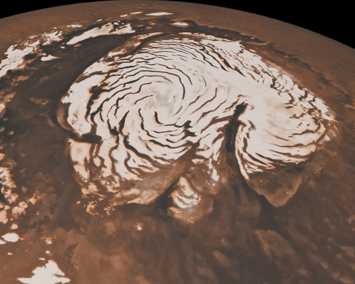
This close-up image of a dust storm on Mars was acquired by the Mars Color Imager instrument on NASA’s Mars Reconnaissance Orbiter on Nov. 7, 2007. Scientists working with NASA’s Curiosity rover were monitoring Mars each day for similar small storms that could either drift over the landing site or stir up dust that moves as haze over the site.
This image is centered on Utopia Planitia, along the north seasonal polar cap edge in late northern winter. When NASA’s Curiosity rover landed on Mars, it was late southern winter. Scientists were looking at similar small storms that form near the south seasonal polar cap edge. The dust storm pictured here was short-lived, lasting less than 24 hours.
The image also shows the seasonal north polar cap (at top of figure) and gravity-wave water ice clouds coming off of Mie crater, just south of the storm. Gravity-wave clouds, also called lee-wave clouds, are clouds that result from changes in atmospheric pressure, temperature, and height because of vertical displacement, such as when wind blows over a mountain or crater wall.
The projection of the image is polar stereographic and the image has a resolution of about 0.6 miles (1 kilometer) per pixel.
Rights
Photos downloaded from the Essential Lens site are cleared for educational use only.