
Essential Science for Teachers: Earth and Space Science
Restless Landscapes Restless Landscapes | A Closer Look
A Closer Look
Look for the following topics in the video, indicated by the ![]() onscreen icon, and click below to learn more.
onscreen icon, and click below to learn more.
 Ice Ages |
 Glaciers |
 Glacial Landforms |
A Closer Look: Ice Ages
What are ice ages?
Ice sheet advance in most recent ice age.
Ice sheet advance in most recent ice age.
Ice ages are recurring periods in the Earth’s history, usually thousands or tens of thousands of years in length, when the entire Earth experiences colder climatic conditions. During these periods, enormous continental glaciers called ice sheets cover large areas of the Earth’s surface. Ice ages are separated by warmer periods called interglacial periods. Several ice ages have occurred throughout our planet’s history. The last ice age peaked about 18,000 years ago, after which the Earth again began to warm.
What causes an ice age?
Ice age intervals seem to correspond with long periods of worldwide climatic cooling. It should be noted that there are numerous factors that affect the Earth’s climate. There are two main natural factors, however, that are thought to influence long-term changes in the Earth’s climate.
Plate Tectonics
- Changes in the positions of the continents are linked to periods of multiple glaciations. The presence of large landmasses at the poles seems to trigger the development of extensive ice sheets. For example, throughout the Ice age that occurred during the Pennsylvanian and Permian geologic eras (250 –350 million years ago), the southern portion of the super-continent Pangaea was at the South Pole. Scientists believe this may have caused extensive glaciation over what are now Africa, South America, India, Antarctica, and Australia.
- Major uplift at continental plate boundaries can cause profound changes in oceanic and atmospheric circulation patterns. Changing circulation patterns cause climate change. Some scientists hypothesize that climatic changes caused by uplift are critical to the development of ice ages.
- Large or numerous volcanic eruptions, also the result of plate tectonics, release huge amounts of gases (carbon dioxide and water vapor) that act to trap heat within the atmosphere, causing global warming (sometimes referred to as the greenhouse effect). In contrast, particles of ash can impact the global climate by reducing the amount of solar radiation reaching Earth’s surface, causing global cooling.
Milankovitch Cycles
Named after the Serbian mathematician Milutin Milankovich, the Milankovitch cycles describe variations in Earth’s position as it orbits the Sun that affect the amount of sunlight it receives. One cycle involves the shape of Earth’s orbit, which varies from being more elliptical to more circular. Another cycle involves Earth’s “tilt” on its axis, which is not perpendicular to the plane of its orbit around the Sun. Presently, Earth tilts 23.5¾ from the perpendicular, but there is evidence that in the past this angle varied from 22¾ to 24¾. A third variation involves Earth’s “wobble.” Like a top wobbling on its axis, Earth wobbles as it orbits. The results are that sometimes the North Pole points to the North Star, and sometimes it points to the star Vega. These cycles vary from tens of thousands to hundreds of thousands of years and can be traced back through the Earth’s geologic record.
When did the ice ages occur?
Several ice ages have occurred throughout our planet’s history. Major periods of glaciations occurred during the late Proterozoic Era (between 600 and 800 million years ago), during the Pennsylvanian and Permian Eras (between about 250 and 350 million years ago), and the late Neocene to Quaternary Eras (the last 4 million years). Somewhat less extensive glaciations occurred during parts of the Ordovician and Silurian Eras (between about 430 and 460 million years ago). The most recent ice age began about 1.8 million years ago during the Pleistocene Era. During this time, giant ice sheets advanced and retreated many times in North America and Europe.
Recent cycles of advancing and retreating ice sheets have occurred approximately every 100,000 years. Each cycle consists of a long, generally cold period during which the ice sheets slowly reach their maximum size, and a relatively short, warm period during which the ice sheets rapidly retreat.
We are now in a warm period that has lasted more than 10,000 years, which is longer than many of the previous warm intervals. If the pattern of glacial cycles holds true, scientists believe the Earth is soon due for another cold period. In the 1800s, global temperatures began decreasing during a period known as the Little Ice Age. Currently, patterns indicate that the Earth is nearing the end of an interglacial period, meaning that another ice age is predicted in a few thousand years.
A Closer Look: Glaciers
What are glaciers?
Glaciers are huge sheets of moving ice that erode the land as they move. Due to their sheer mass, glaciers flow like very slow rivers. Glaciers store about 75% of the world’s freshwater. Some glaciers are as small as football fields, while others grow to be over one hundred kilometers long (about 100,000 football fields, or 62.2 miles).
How do they form?
Glaciers begin to form when snow accumulates and remains in an area year-round. If temperatures do not rise enough to completely melt the snow, snow continues to accumulate. Each year, new layers of snow bury and compress the previous layers. The weight of the overlying snow puts enough pressure on the bottommost snow layers to compress them into large, thickened ice masses. This compression forces the snow to re-crystallize. During recrystallization, the crystals interlock to create ice that essentially behaves like rock. Once a mass of compressed ice reaches a critical thickness, it becomes so heavy that it begins to move.
How do glaciers move?
- Internal deformation: Ice buckles under its own weight because of gravity. As this happens, the mass of ice crystals in the glacier slowly changes shape without completely breaking or melting, causing it to flow downward or outward. The thicker and warmer the ice is, the faster the flow. Movement of a glacier by internal deformation is very slow, on the order of tens of meters per year.
- Basal sliding: Basal sliding occurs when water is present under the glacier. Water is formed toward the bottom of the glacier because of the pressure of the overlying ice. This melt water reduces friction and allows the ice to move more quickly. Water may also come from surface water that has worked its way through the cracks in the ice. Or, it may originate from melting upstream in the glacier.
- Deforming substrate: Water is not the only material that can cause sliding. The rock debris under the ice sheet can also increase movement at the base of a glacier. If the glacier is sitting on a soft or loose bed of sediment that contains water, the sediment can move and carry the ice sheet with it.
What are some glacial features?
The glacier terminus is the leading edge of a glacier. The accumulation zone is the area where snowfall is added (usually near the top of the glacier). The ablation zone is the area of the glacier where glacial ice is being lost through evaporation, melting, or calving (see below). When a glacier flows rapidly over uneven land, the top of the glacier bends and breaks, creating huge cracks called crevasses. Internal stresses build up in the ice that cannot be relieved by internal deformation alone, and crevasses form at the surface of the glacier. Glaciers leave grooves, gouges, and scratches on the landscape called glacial striations that record their passage.
What are the different kinds of glaciers?
- Ice sheets, ice caps, and ice fields are all masses of glacial ice of various sizes that spread laterally across the landscape and vary in size. Ice caps are smaller than ice sheets. Ice fields are similar to ice caps, but are typically smaller, and are therefore more influenced by the underlying topography.
- Ice shelves occur when ice sheets extend over water. They are large, flat-topped sheets of ice that are attached to land along one side and float in an ocean or lake on the other side.
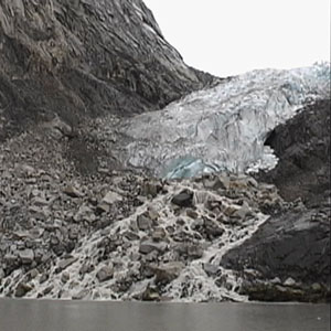
Glacial melt from an alpine glacier.
- Mountain (Alpine) glaciers develop in high mountainous regions, often flowing out of ice fields. The topographical features of the surrounding mountains define their shape and control the direction of their flow. Mountain glaciers include cirque glaciers, named for the bowl-shaped depressions they occupy; piedmont glaciers, which occur when steep valley glaciers spill out into relatively flat plains; and valley glaciers that flow within the walls of a mountain or river valley. Valley glaciers may be very long, often flowing far enough to reach sea level.
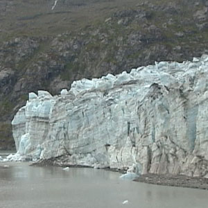
- Tidewater glaciers are valley glaciers that flow far enough to reach out into the sea. Tidewater glaciers “calve,” which is when portions of a glacier break off into the sea, becoming small icebergs.
- Hanging glaciers cling to steep mountain slopes and terminate at or near the top of a cliff; they are wider than they are long. Hanging glaciers are common in the Alps, where they often cause avalanches due to the steep slopes with which they are associated.
A Closer Look: Glacial Landforms
What are examples of landforms created by glacial erosion?
As a glacier moves, it picks up rock pieces from the landscape. Debris of all sizes that is stuck in the glacial ice can scour and erode the land. From this action, valleys can become wider and deeper, forming u-shaped (or trough) valleys. Glaciers can carve bowl-shaped depressions, called cirques, into a mountainside. A tarn is a lake that forms by ice melting in a cirque. An arête is the steep ridge that forms between two adjacent cirques. A col is a low spot on an arête. A horn is a peak formed when three or more adjacent cirque glaciers carve away the side of a mountain.
Continental glaciers scour linear finger lakes out of pre-existing stream channels. Paternoster lakes are a series of lakes that form in the low spots of a u-shaped valley; a stream that flows through the valley links them.
What are some landforms created by glacial deposition?
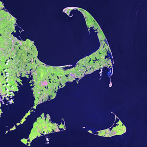
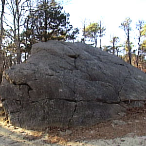
Cape Cod, Massachusetts
A glacier will deposit rock chunks along the sides and the front of it. Moraines are created when a glacier pushes or carries along this rock debris as it moves, and then deposits it. Moraines can form in front of a glacier (terminal or end moraine) marking the furthest position of advance of an ice sheet; along the side of a glacier (lateral moraine); or under a glacier (ground moraine). When two glaciers flow next to each other they deposit lateral moraines between them called medial moraines. Long Island, New York and Cape Cod, Massachusetts are examples of terminal moraines of the ice sheet that covered New England and eastern Canada during the last ice age.
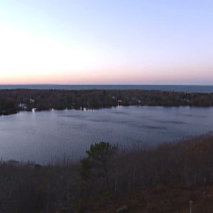
Kettle pond on Cape Cod, Massachusetts
Drumlins are elongated hills formed of till (an unsorted mixture of mud, sand, pebbles and rock deposited by a glacier) with a distinctive streamline shape that results from having been overridden by a glacier or modified by meltwater. The long axis of a drumlin indicates the direction of glacier flow. Eskers are the deposits of rivers and streams that flowed on, in, or under a glacier. They form mounds or hills that meander across a landscape roughly parallel to the path of the original glacial river. Kettle holes are formed by blocks of ice that separate from the main glacier. Under the right conditions the ice blocks will melt and leave behind holes or depressions that fill with water to become kettle ponds or kettle lakes.